Mapping with drones is done using a technique called Photogrammetry. Photogrammetry is the science of making measurements from Photographs.Multiple overlapping photos of the ground below are captured as the aircraft flies autonomously along a flight path that we specify beforehand. The data they collect assist in the creation of maps, plots, and legal documentation. With maps as a crucial part of their job, there is no doubt that drone photogrammetry is the way forward in terms of digitization and accuracy of land. In case you are interested and want to explore with us, we are just a WhatsApp away.
Mapping Drones
PRODUCTS
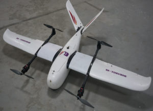
Hornbill-05
The HornBill 05 is a flight with industrial class aerial survey capabilities. It is portable, easy to operate, and very stable and durable. The beautifully modular design makes topography simple and easy. Quick detachable wings, ventral shock absorption, and energy release enable the aircraft to have good portability and excellent user experience. The battery compartment can accommodate a 6S 22000mah Lipo battery, bringing long battery life and time in the air to get the photos you need.


